


Submitted Graphic
The North Country Trail provides about 455 miles of hiking path in North Dakota. Map from the North Country Trail Association.
Hiking North Dakota’s open prairies and lake shores exposes an aspect of the state’s beauty that can’t be seen except up-close.
Thanks to the contributions of numerous volunteers, North Dakota’s portion of the North Country National Scenic Trail offers local and visiting hikers a groomed path to explore wildlife habitat, discover out-of-the-way communities and experience the state’s only waterfall.
North Dakota’s current 455 miles of hiking trails exist as part of the larger 4,800-mile North Country Trail, which runs between Lake Sakakawea and Vermont. According to the North Country Trail Association (NCTA), the trail traverses forests and farmland, remote terrain and bustling communities in eight states.
The North Country Trail is under the umbrella of the National Park Service, which provides some funding, but the work of developing and maintaining the trail falls to the volunteer chapters of NCTA.
Last year, North Dakota’s Central Flyway Chapter opened a new segment of trail along Lake Sakawea, replacing a previous trail that utilized a highway.
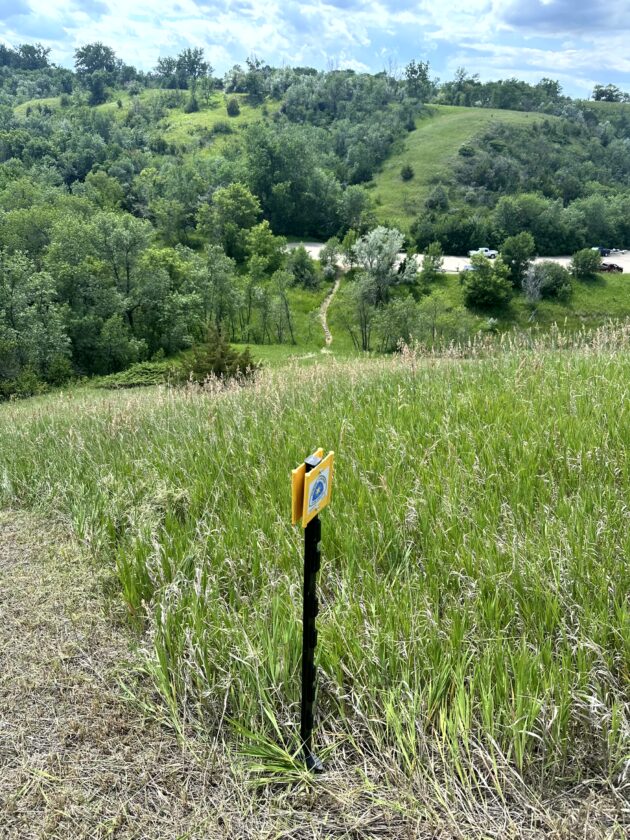
Submitted Photo
A marker designates the North Country Trail around Riverdale.
Glee Mayer, Minot, Central Flyway vice president, said the Army Corps of Engineers gave permission in March 2025 to lay out a route on its property. She walked the area, identifying areas that provided beautiful views of lake Sakakawea. The chapter presented its proposal to the Corps, which gave the green light to mow and sign that updated segment of the trail, she said.
“The reception has been really good because the views from that section of the trail are pretty amazing,” Mayer said. “You have the beautiful prairie grasses, and there are some trees, but just the views of the lake are pretty amazing.”
“When we took the trail off the highway, we took it down around the fish hatchery property, and again, people were able to see the Missouri River, experience a little bit of the Lewis and Clark history on the Missouri River,” added Central Flyway president Mark Zimmerman, Bismarck. “We opened it up to more exciting hiking when they’re off the highway and on the trail.”
The newest section was dedicated with a ribbon cutting in August 2025, when a celebratory Hike Fest drew walkers from a number of states to walk portions of the North Dakota trail section.
Zimmerman said the North Country Trail’s west terminus at Lake Sakakawea State Park is a popular starting point for hikers looking to eventually cover the entire distance of the trail. He said a number of those trail travelers are making their first visit to North Dakota.
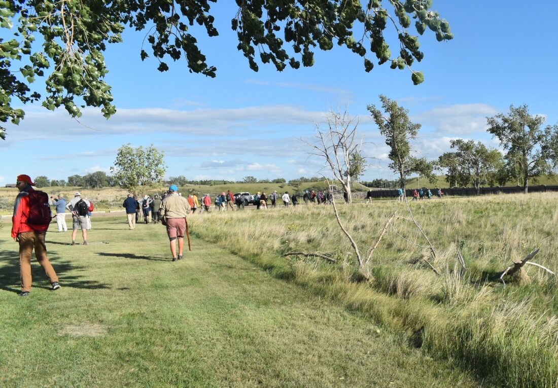
Submitted Photo
Hikers take part in the four-day Hike Fest, a celebration of the North Country National Scenic Trail organized by the three volunteer chapters in North Dakota in August 2025. About 100 outdoor enthusiasts from across the country took part.
“Their comments, coming to the prairie is ‘It’s amazing,’” Zimmerman said. “One couple,from the Minneapolis suburbs – I helped shuttle them a couple days – they had hiked in Africa on the Serengeti, and they said walking the prairie at the refuge reminded them of being on the Serengeti – the tall grass waving and seeing deer and seeing birds.”
There are various trailheads from which people can launch shorter hikes, with parking available at the state park, refuge, Riverdale or the hatchery for accessing those trailheads.
“There’s plenty of access points and that’s why we’re working on trailhead maps and a brochure,” Zimmerman said. “Not everybody wants to hike, 10-12, miles a day, but we want folks to get out on the trail.”
Mayer recalled an event a couple of years ago on National Trails Day. Hikers scattered across the North Country Trail in North Dakota to together cover every mile in a single day.
“I think we had 200 and some people out on the trail on that day in June,” she said.
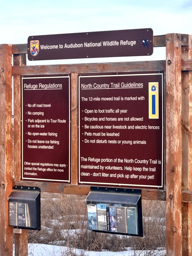
Submitted Photo
A North Country Trail kiosk stands in the Audubon National Wildlife Refuge.
The North Country Trail Association has a program that awards patches for completing 100 miles of hiking on the trail.
A North Dakota challenge, called the Dakota Challenge, rewards people who complete the state’s portion of the trail system. As of earlier this year, about a dozen people have completed the challenge, said Mayer, who is one of them. Mayer called it an educational experience.
“It’s pretty interesting. what you learn. Towns I didn’t know existed,” Mayer said.
The Dakota Challenge is organized through the Dakota Prairie Chapter in eastern North Dakota but information is available through any of the state’s three local chapters.
North Dakota Parks and Recreation also has offered encouragement with its programming that promotes the North Country Trail.
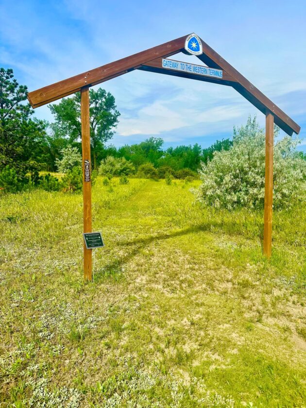
Submitted Photo
A gateway sign welcomes hikers to the western terminus of the North Country Trail at Lake Sakakawea State Park.
“We work with the state park. We work with wildlife. We work with the Army Corps of Engineers,” Mayer said of volunteers. “The cooperation from all of those government agencies in helping us develop the trail and maintain the trail and promote the trail is amazing. Down at the hatchery, they had this wonderful trail system set up down there years ago that nobody was utilizing. So, when we reached out to see if we could put the trail through the hatchery, they were very receptive, and they have done an amazing job of helping us promote, and they think one of the best things that’s happened to the hatchery is having the trail come through there. It has brought people to the hatchery that might otherwise not have come.”
Zimmerman said Central Flyway offers an annual hike on the hatchery property in October when the salmon are running. Hikers can view the salmon swimming upstream to the hatchery to lay their eggs.
“We had 80 people this past October. The fish are always there,” he said. “Some of them will kind of jump out of the water as they swim upstream.”
Volunteers promote the trail and organize hikes, but they also mow and sign trails and stock map holders.
“We are always looking for volunteers,” Zimmerman said. Volunteers don’t have to be hikers if they enjoy riding mowers. Service clubs or other groups that are looking for projects also are welcome to check out the opportunities.
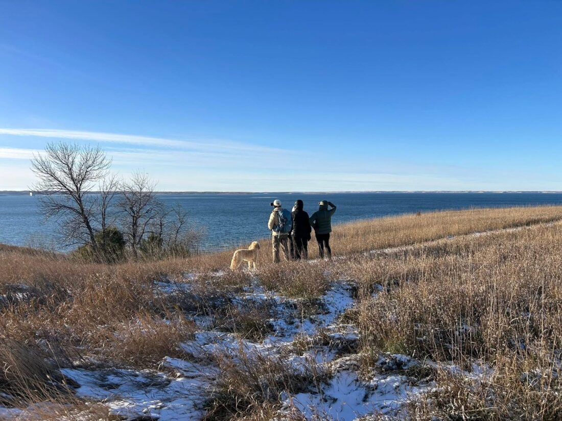
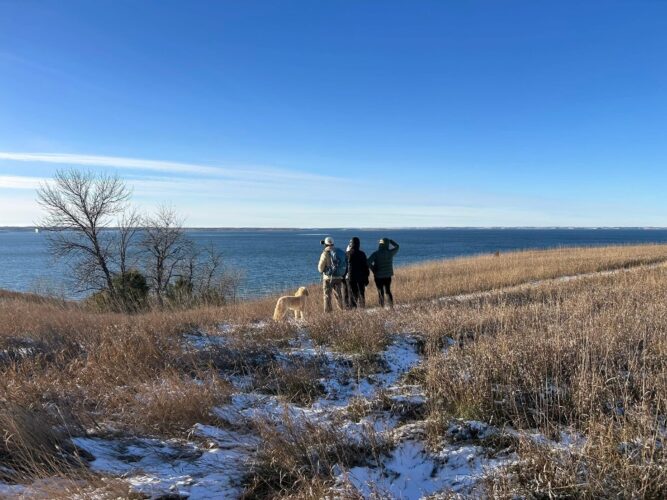
Submitted Photo
Hikers enjoy the scenery of the North Country Trail portion near Riverdale during a November hike.
The national North Country Trail Association has a number of online resources to help people learn more, get connected with a chapter or download free hiking maps.
The National Park Service provides tools, training and some funding to enable the nonprofit NCTA, in a cooperative agreement, to organize the volunteers and advance the trail.
The trail system could not exist without volunteers, said Matt Davis, NCTA regional trail coordinator for North Dakota, Minnesota and Wisconsin.
“A chapter in Michigan might have 300, 400, 500 members. In North Dakota, it might have 60. It’s a smaller group of people and so they work more closely together. They partner on events,” he said. “It’s this tight knit community that’s always welcoming of new folks to get involved. And our volunteers just love showing off the trail.”
The trail through North Dakota isn’t fully completed yet, however.
Along the Central Flyway, the biggest gap in the trail system exists between Riverdale and the Audubon National Wildlife Refuge, Davis said.
Currently, that trail segment runs along roads, crossing U.S. 83 at Coleharbor before winding its way to the north. The land was acquired by the U.S. Corps of Engineers when the Garrison Dam was built but is managed by the North Dakota Game & Fish Department.
The department has hesitated to support a marked trail system due to concerns about habitat fragmentation, Davis said. The association hopes to craft a proposal to mitigate that concern, he said.
“We want to try and find a win-win – something that’s going to benefit sportsmen, benefit hikers. Really, what we want to do is bring more people to experience those beautiful public lands,” he said.
Closing gaps is essential to doing that, he indicated. A few years ago a portion of the trail was relocated off the McClusky Canal and through the Brekken-Holmes Recreation Area near Turtle Lake.
“The wildlife are outstanding. The views are incredible. But right now, nobody’s really driving up there because of that big, long roadblock section in the middle,” Davis said. “If we could close that donut, it would be a fantastic hiking experience.”
The largest gap in the entire North Country Trail system lies in North Dakota from the end of the New Rockford Canal, east of New Rockford, to the north end of Lake Ashtabula, north of Valley City, Davis said. There aren’t large blocks of public land other than waterfowl production areas, and wetlands don’t serve well for hiking, he said. Consequently, the trail runs along public roads.
A lack of public lands south of Lake Ashtabula and around Valley City, also is an obstacle to trail development there.
“Our volunteers are out there talking with landowners, trying to get easements to get the trail off of the road,” he said. “We try to make it as least intrusive as we can on those landowners and their grazing operations. We’ll put up signs telling hikers how to safely hike around cattle. Don’t leave gates open. So, we really strive hard to be a good neighbor with people who host the trail.”
Davis estimated the trail association has about 50 easements with private landowners across the trail in North Dakota currently.
Davis said it can be difficult to recruit volunteers in areas where there are gaps because of uncertainty about where the trail is meant to go. He explained the National Park Service originally planned for the trail to run from New Rockford to Fort Totten and through White Bird Hill National Game Refuge, formerly Sully’s Hill. It then was to follow the south shore of Devils Lake to Stump Lake before heading southeast to Lake Ashtabula and into the Sheyenne River Valley. The current route came about based on availability of volunteers to organize a trail, he said.
Because the proposed and current routes now differ, the trail association would like to see the National Park Service lead a planning effort to figure out a forever home for the trail system, he said.
The trail system through North Dakota is popular with hikers from across the country because its wide open spaces contrast with forested and mountainous trails found elsewhere, Davis said.
“it’s completely different, and people love it,” he said. “The wildlife are different. The sunsets are incredible. If we had a contiguous trail all across North Dakota, we’d be getting a lot more people to come hike it, just because North Dakota is so beautiful and unique.”
ND’s volunteer chapters maintain trail
The North Country Trail Association in North Dakota consists of three chapters. The Central Flyway Chapter, the Sheyenne River Valley and Dakota Prairie chapters maintain trail segments that extend eastward to its exit in the state’s southeast corner.
The Central Flyway Chapter’s area runs from the terminus of the 4,800-mile national trail at Lake Sakakawea State Park through the Audubon National Wildlife Refuge to the east side of Lonetree Wildlife Management Area.
The trail meanders across rolling grasslands with abundant prairie pothole wetlands. It follows the McClusky Canal for about 75 miles and offers a variety of wildlife habitats in the Lonetree area. Amenities along the trail include backcountry campsites, public campgrounds, small towns, public recreation areas and tourist/historic sites.
The Sheyenne River Valley Chapter takes the trail from the New Rockford Canal to Lake Ashtabula and Fort Ransom State Park.
Sheyenne Valley Chapter President Becky Heise said the chapter will be constructing a reroute this year to replace a portion of trail that has been plagued with slumping along Lake Ashtabula.
Existing trail highlights include:
– The segment south of the West Ashtabula Campground, affectionately referred to as the Badlands of the Baldhills for its clay buttes, travels through grazed pastures along the north side of Baldhill Creek through the Wieland Wildlife Management Area, which offers and unique plant communities, including prickly pear, sagebrush and yucca.
– The Ladies Line trail from Kathryn to Clausen Springs Recreation Area is a 5.4 mile segment consisting of 4.5 miles of abandoned rail bed. Of special interest is a 1.8 mile loop following the shores of Clausen Springs Lake. The trail offers pretty lake views, several secluded camping and picnic areas, pine forest and a trek across an earthen dam.
– The trail through Fort Ransom State Park follows the west bank of the Sheyenne River and includes views of hay fields and restored native prairie. Views of the park’s Sunne Farm can be seen before the trail drops into a wooded section on the riverbank.
– The trail through the Sheyenne State Forest winds through bottomland and upland forests with scenic areas overlooking the river valley.
– The waterfall segment is a wooded and serene hike along an old abandoned roadbed. The waterfall, the only registered waterfall in the state, flows year-round and is the site of one of the back country campsites.
The Dakota Prairie Chapter manages the trail from the Sheyenne National Grasslands to Fort Abercrombie, south of Wahpeton, which is the eastern terminus of the trail in North Dakota. It includes the Albert Ekre Grassland Preserve, a living laboratory for studying plant, animal and range sciences, while providing summer grazing for livestock and hosting hiking trails. Two log cabins located on the farmstead are being restored by the land owner and are planned to be opened to the public, according to Dakota Prairie Chapter President Bill Stone.
The Biesterfeldt site, a mile west of the West Trailhead of the Sheyenne National Grasslands, is an archaeological site of an earthen lodge village occupied by the Cheyenne Indians 1724-1780. A replica of an earthen hut, built and maintained by a Dakota Prairie Chapter member, can be seen at the McLeod Museum in the nearby town of McLeod.
Lisbon, a trail town, includes the Opera House, built in 1889, and the Scenic Theater, which is the oldest continuously operating movie theater in the United States. The founder of the Boy Scouts of America, W.D. Boyce, lived in Lisbon for eight years.
During 2026, the Dakota Prairie Chapter intends to assist U.S. Forest Service personnel, if requested, in a trail maintenance project on the Sheyenne National Grasslands, along with its usual, continual trail maintenance.
Upcoming 2026 Events
The Three Chapters North Country Trail Hiking Festival will be held Aug. 14-16. Members from North Dakota’s three chapters will gather in Abercrombie to camp, hike, learn about the history of the area and socialize with fellow members. The event includes four hikes, music and dinner along the Wild Rice.
Further hiking events can be found on the social media pages of each of the chapters as new events are added. A number of events already are scheduled with dates or tentative dates released.
Central Flyway Chapter:
– “Awakening of the Hatchery,” April 15-May 10, Garrison National Fish Hatchery, self-guided.
– Hatchery Fun Day, May 23, Garrison Dam National Fish hatchery, guided hikes.
– National Trails Day “Riverdale History Hike,” guided hike.
– Salmon Run Hike, Oct. 10-11, Garrison Dam National Fish Hatchery.
Dakota Prairie Chapter:
– Hike the Half, to be scheduled in late September or early October, is an annual event in which hikers challenge themselves to complete a 13.1 mile trek on the North Country Trail. The route changes each year. Last year about 85 people participated.
– Halloween Hike, to be scheduled in late October, is a family friendly casual hike for all ages, complete with costumes, tricks and treats. It is an approximately 2.5 mile hike, with a chance to learn about nature and encounter a few ghosts and goblins along the way.
Sheyenne River Valley Chapter:
– Crocus Hike, May 2, at 8:30 a.m., an approximate 5-mile hike from the Clausen Springs Recreation Area trailhead.
– Valley City hike, May 21, at 6:30 p.m., 4-mile round trip from Medicine Wheel Park to the Dairy Queen or shuttle back for a 2-mile trip.
– National Trails Day, June 6, at 10 a.m., hike from Clausen Springs Recreation Area to Kathryn, includes canoe/kayak around the lake.
– That Dam Hike, July 18, 8:30 a.m., 6.5-mile hike from Katie Olson trailhead to Baldhill Dam.
– Night Hike, Aug. 7, 8 p.m., Fort Ransom State Park.
– Fort Ransom Hike, Sept. 6, 10 a.m., a 5-mile hike out and back or 2.5-mile hike with shuttle back.
– Waterfall Hike, Sept. 26, 2 p.m., 4.4-mile hike from Martinson Bridge trailhead to the waterfall.
– Halloween Hike, Oct. 24, 5:30 p.m., from Medicine Wheel Park to the Dairy Queen in Valley City. Free small ice cream treats.
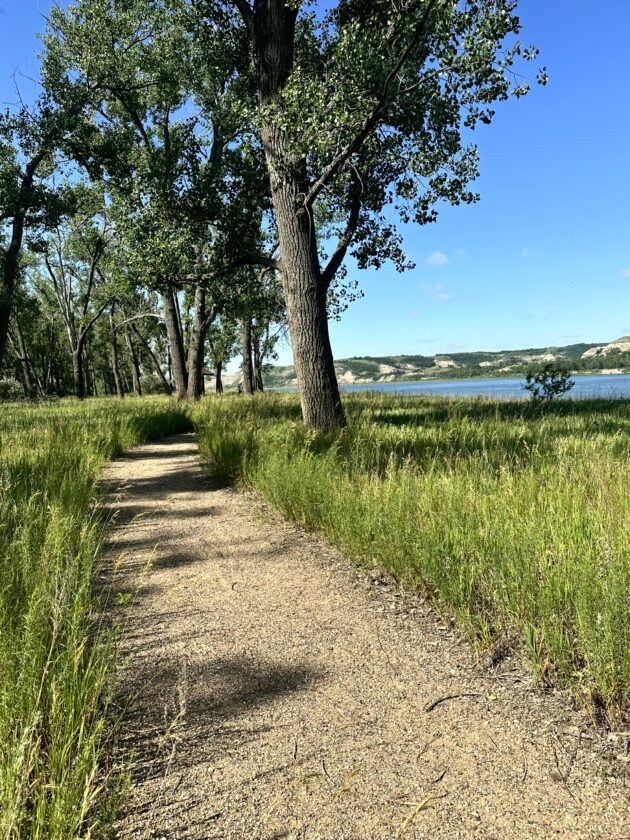
Submitted Photo
The North Country Trail follows along the Missouri River in the Garrison Dam National Hatchery.
WATFORD CITY — A 63-year-old Watford City woman died from injuries received in a two-vehicle crash at the …
BISMARCK – City officials from across North Dakota were recognized for leadership development during the North …
The Central Dakota Metropolitan Planning Organization (CDMPO) invites the public to review the draft Transit …
WILLISTON — Williston State College announced it has expanded its Degree Bridge program through new …